There are 2 ways to find your specific property map; use the legal description or use the parcel ID#.
#1. Legal description: Match the Township/Range/Section with map selection; example below.
Example Legal Description:
- THE E 1/2 OF THE SE 1/4 OF THE SW 1/4 OF THE SW 1/4 OF SEC 36, T25N R2W, CONTAINING 5 ACRES OF LAND SUBJECT TO A 33 FT ROW OF STATE HWY M-144 ALONG S’LY SIDE THEREOF. SUBJECT TO RESTRICTIONS, RESERVATIONS AND EASEMENTS, IF ANY OF RECORD. = Map – T25N-R2W SEC 36
#2. Parcel ID#: Match the first two sets of 3-digit numbers in the parcel ID# with map selection.
- Parcel ID# 062-036-011-100-00 = Map – T25N-R2W SEC 36
Next: Look to the remaining digits to find your parcel on the map.
*Note: Not all parcel numbers are listed if lot sizes are very small.
Special Note: Regarding Parcel #s beginning with #064 – All parcels beginning with #064 represent properties within platted subdivisions which are interspersed within the Township/Ranges identified under #061, #062, & #063. Please see the “Parcel ID Beginning with #064 – Platted Subdivisions” link under Zoning Maps for a chart which lists the names of the Platted Subdivisions, the correct Township/Range map designations, and the approximate cross-street intersection for the subdivision locations.
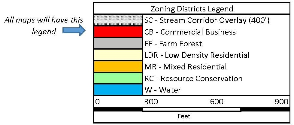
Finally: Each map has a legend showing the color codes for each zoning district. Once you know your zoning district, if you would like, you are welcome to read all about the district regulations for your particular district in our Zoning Ordinance located in Article 5, Sections 5.01 through 5.08.
If you need assistance, whether it is with finding the appropriate zoning district for your property, questions about the district regulations, or any other zoning questions you may have, please contact the Zoning Administrator via email at zoningadmin@southbranchtownship.com or by phone at 989-275-8232.